
At the suggestions of Cajun Squealer I thought I would post up over here.
All,
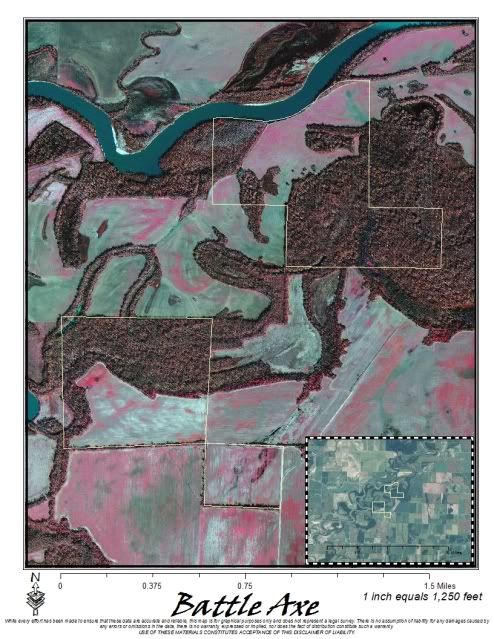
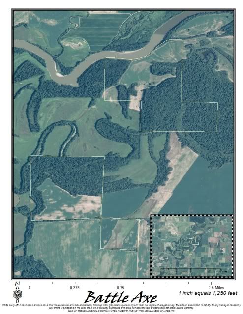
I am producing large size High Resolution Aerial Photography Maps. I can provide current imagery from most states including both public and private lands. These maps can be printed on glossy photopaper or laminated and come in 24"x36", 36"x48" and 40"x60". If you would like more information send an email with any questions to:
ProvenMaps@gmail.com
High Resolution Aerial Photography Maps
-
novacaine
- Duck South Addict
- Posts: 3605
- Joined: Sun Oct 26, 2008 8:59 pm
- Location: Hernando-Gwood-Nola
Re: High Resolution Aerial Photography Maps
What year imagery are you using?
"You didn't happen to find that on the side of the road did you?"- One Shot
Re: High Resolution Aerial Photography Maps
I have 2009 natural color...some IR from previous years for certain areasnovacaine wrote:What year imagery are you using?

Re: High Resolution Aerial Photography Maps
IMHO, the best "natural color" maps should be taken in the winter on a sunny day similar to those on "bird's eye view". This shows the differentiation between hardwoods and pines etc due to the foilage being off the hardwoods.
It's better to have it and not need it, than need it and not have it.
Re: High Resolution Aerial Photography Maps
Yes IR show better detail in the water in most case..I'm always working on adding more imagery to my libraryDutch Dog wrote:IMHO, the best "natural color" maps should be taken in the winter on a sunny day similar to those on "bird's eye view". This shows the differentiation between hardwoods and pines etc due to the foilage being off the hardwoods.
Re: High Resolution Aerial Photography Maps
Post up a couple of samples.
Re: High Resolution Aerial Photography Maps
I'll post some samples up this afternoon when I get home.
Thanks!
Thanks!
-
mudsucker

- Duck South Addict
- Posts: 14137
- Joined: Wed Oct 29, 2003 4:15 am
- Location: Brandon,Ms by way of LaBranche Wetlands
Re: High Resolution Aerial Photography Maps
Now post Mahannah.
Long Live the Black Democrat!
GEAUX LSU!
WHO DAT!
DO,DU AND DW!
GEAUX LSU!
WHO DAT!
DO,DU AND DW!

-
deltadukman
- Duck South Addict
- Posts: 7779
- Joined: Sun Dec 07, 2003 11:04 pm
- Location: Crunksippi
Re: High Resolution Aerial Photography Maps
That place will be covered up with Albaninans this year...hide and watch...50-11 of em....like flies on a dogs booty, or stink on chit...ducks or no ducks...Albanians will be there...bet that...fo sho
-
Buckwabit

- Duck South Addict
- Posts: 3350
- Joined: Tue Feb 07, 2006 3:31 pm
- Location: PTown if you down....
Re: High Resolution Aerial Photography Maps
I was waiting on that...funny as hell. You always have a way with words....deltadukman wrote:That place will be covered up with Albaninans this year...hide and watch...50-11 of em....like flies on a dogs booty, or stink on chit...ducks or no ducks...Albanians will be there...bet that...fo sho
Chad Miley
I love the "Ole Man"..Plenty of Birds and No Company...
I love the "Ole Man"..Plenty of Birds and No Company...

Re: High Resolution Aerial Photography Maps
Nice aerial photos cuz! Maybe I will be able to make it that way and try to get a few ducks this season.Pas Bon wrote:Samples
brake man
-
mudsucker
- Duck South Addict
- Posts: 14137
- Joined: Wed Oct 29, 2003 4:15 am
- Location: Brandon,Ms by way of LaBranche Wetlands
Re: High Resolution Aerial Photography Maps
No good without GPS cord.Pas Bon wrote:Samples
Long Live the Black Democrat!
GEAUX LSU!
WHO DAT!
DO,DU AND DW!
GEAUX LSU!
WHO DAT!
DO,DU AND DW!
Re: High Resolution Aerial Photography Maps
mudsucker,
Don't worry about GPS coordinates since there aren't any ducks in that part of Alabama.
brake man
Don't worry about GPS coordinates since there aren't any ducks in that part of Alabama.
brake man
brake man
Who is online
Users browsing this forum: Bing [Bot] and 3 guests