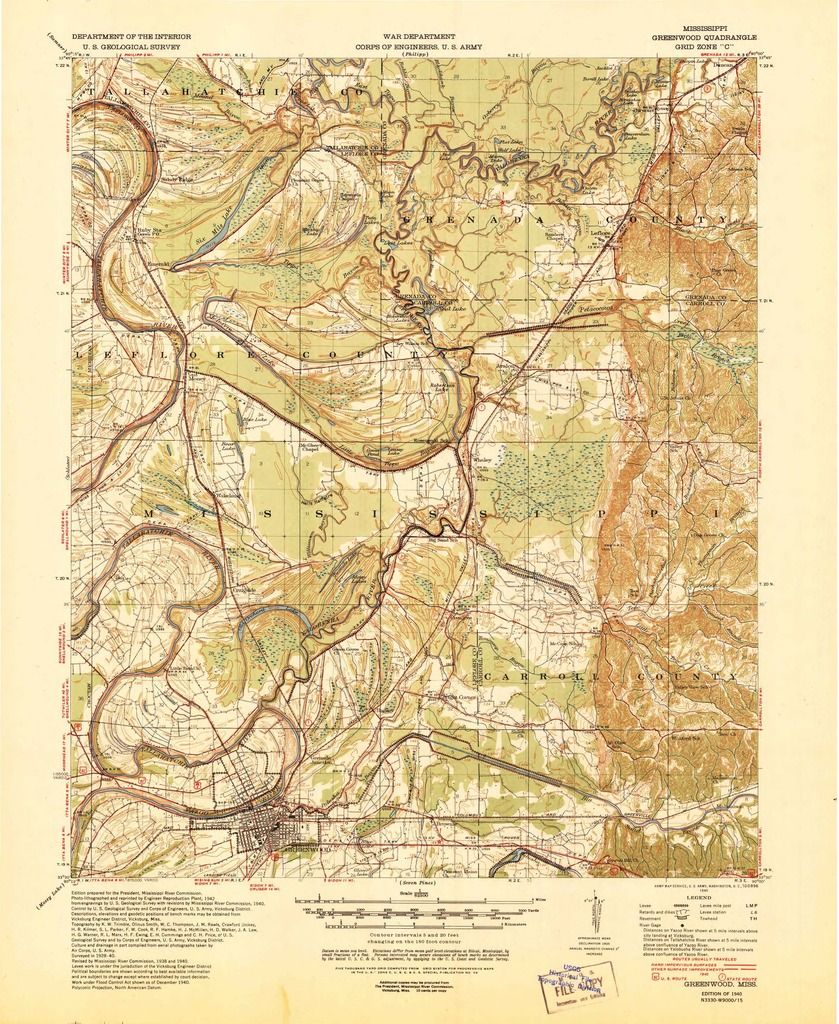
Hosemann steals six mile lake!
Re: WHAT A CROCK
Peewee - The meeting at Hinds CC was not a Commission meeting but a regional meeting to get public input on WMA regulations. That public input is then relayed up the chain of command to be considered in the decision making process.
Scott Baker
-
rjohnson

- Duck South Addict
- Posts: 4895
- Joined: Mon Jan 17, 2005 11:28 am
- Location: Brandon, MS
- Contact:
Re: WHAT A CROCK
Massachusetts out of all places you would think has a law that says you can hunt anywhere under the high tide line. I mean you can setup shop in front of a multi-million dollar mansion in Boston Harbor and hunt as long as you want. In a state where you would think they would crucify hunting they had enough common sense a long long time ago to set this in place. It's a simple rule much like what we should have here that doesn't fluctuate or change depending on adjacent landowners and their personal interests. It should be cut and dry. If it is navigable waterway or lake or it is simply open to the public inside the normal banks including any timber that might be flooded during higher water inside the banks. I don't hunt any of the places that have theses varying rules of "encroachment" but the feeling I get is it's all personal interests, good ole boy deals, and backdoor loopholes being exploited so a few people gain while the general public loses. But that's not surprising, shocking, whatever you want to call it due this being the most corrupt state in the union when it comes to stuff like this. Either you are in or you are out and in this case the public isn't in as usual. Hopefully a lawyer or two interested in hunting the area will put in some pro bono work and make sure this deal either benefits the public in the long run with more acreage to hunt or helps put a stop to it being a sanctuary. At the very least make sure it was done legally and let the powers that be know the public is watching their every move when it comes to changing any public hunting opportunities.adame wrote:This is why I love Idaho. I can go on any waterway as long as that I'm under the high water line.
http://www.lithicIT.com My biz
Re: WHAT A CROCK
I am against it I like the water being low and being able to stand against a tree. I don't hunt six mile but I still think it is a bunch of b.s. This state has gone to hell.
GRENADA MAFIA
HR Wood's Henna Sag aka Sage
HRCH Ten Bears They Call Me Trouble MH aka Trouble
My Rook Takes The Trick aka Rook
HR Wood's Henna Sag aka Sage
HRCH Ten Bears They Call Me Trouble MH aka Trouble
My Rook Takes The Trick aka Rook
-
Don Miller
- Duck South Addict
- Posts: 6430
- Joined: Wed Nov 07, 2001 1:01 am
- Location: Holcomb/Money, MS
- Contact:
Re: WHAT A CROCK
WOW!!!! Politics has made some strange bed fellows on this shady "Refuge" deal.
Last edited by Don Miller on Fri Aug 21, 2015 1:32 pm, edited 1 time in total.
"I'd still like to stick that shotgun up a mallard's as$ and pull the trigger!"---FRITZ RUESEWALD @ 93 years old...(The Arkansas Duck Hunter's Almanac, pg.91)
Re: WHAT A CROCK
Tippo Bayou drains a large area spanning from Money-Whaley Rd on the south end to well above Hwy 8 on the north end. Six Mile, Scatters, McIntyre Lake historically drained east through Little Tippo Bayou to the Yalobusha River. Naturally, water levels were tied to that of the Yalobusha River.
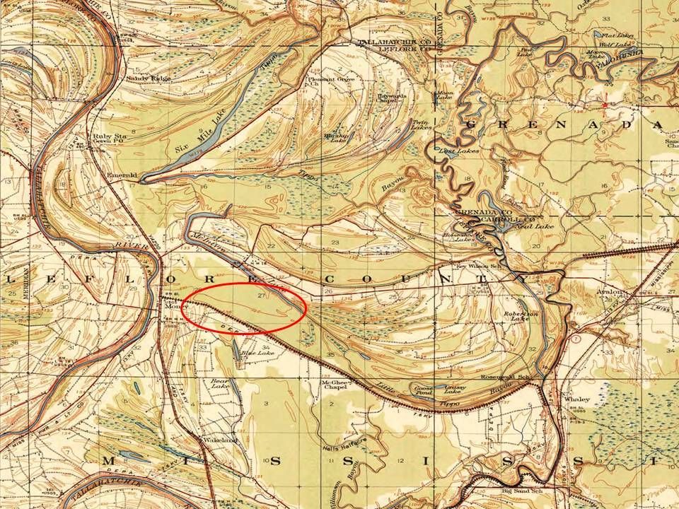
Topo maps from the 1940's show a 125' ridge line southwest of McIntyre Lake that prevented water from draining to the Tallahatchie unless it was higher than 125'.
1957 aerial photo depicting this area in mature hardwood timber.
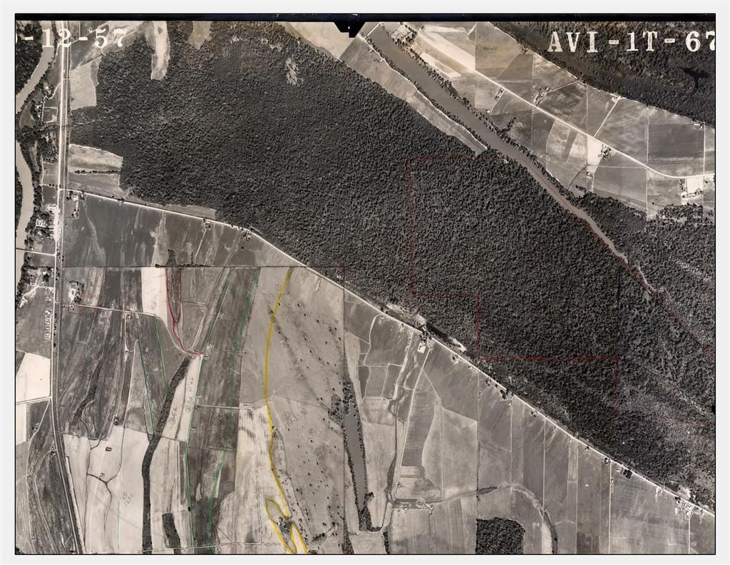
1966 aerial photo depicting clearing and windrowing of timber.

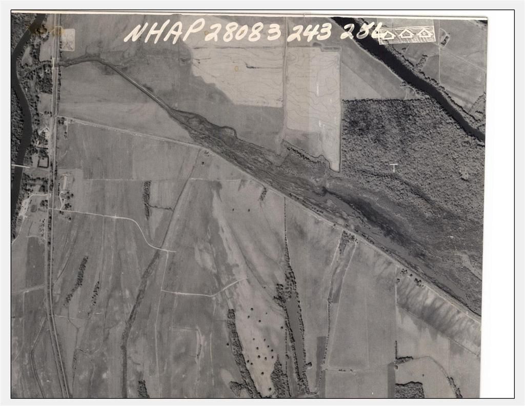
1983 aerial photo depicting a man-made ditch cut through the 125' ridge line draining water back to the Tallahatchie. This drainage is now referred to as Money Bayou.
The Tallahatchie generally runs 3-4 ft lower than the Yalobusha, so when the ditch was cut water immediately started flowing to west. At Yalobusha River levels above 117' water actually runs from the Yalobusha to the Tallahatchie. All of this water flow, plus dredging of the Tallahatchie, has caused Money Bayou to erode and head cut substantially. Channel bottom elevation at the weir location is approximately 110.5'.
The weir is proposed to be installed in the historic 125' ridge at an elevation of 124' msl.
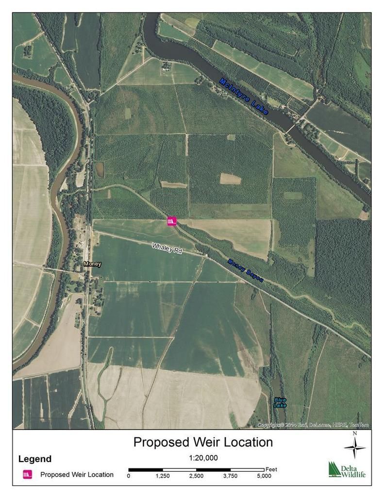
With the weir in place, water levels in McIntyre, Scatters, Six Mile, etc will once again be determined by the Yalobusha River. THIS IS IMPORTANT - THE WEIR WILL NOT SET THE WATER LEVEL ONLY REVERT IT BACK TO ITS NATURAL OUTLET.
With that said, let’s take a look at the Yalobusha River levels to see what we can expect on McIntyre, Scatters, Six Mile, etc. We pulled river level data from the Yalobusha gauge at Whaley from 1980-2014. Monthly average water levels are listed below.
January - 125.9'
February - 126.1'
March - 124.9'
April - 122.9'
May - 121.3'
June - 120.9'
July - 120.7'
August - 121.6'
September - 122.7'
October - 122.8'
November - 123.2'
December - 124.3'
As a staff person for Delta Wildlife I have been involved with the technical side of the weir project since the beginning. I cannot speak to the “refuge” designation of the land donation because we were not aware of this until the press release came out earlier in the week.
Dan Prevost
Biologist/Forester
Delta Wildlife

Topo maps from the 1940's show a 125' ridge line southwest of McIntyre Lake that prevented water from draining to the Tallahatchie unless it was higher than 125'.

1957 aerial photo depicting this area in mature hardwood timber.

1966 aerial photo depicting clearing and windrowing of timber.

1983 aerial photo depicting a man-made ditch cut through the 125' ridge line draining water back to the Tallahatchie. This drainage is now referred to as Money Bayou.

The Tallahatchie generally runs 3-4 ft lower than the Yalobusha, so when the ditch was cut water immediately started flowing to west. At Yalobusha River levels above 117' water actually runs from the Yalobusha to the Tallahatchie. All of this water flow, plus dredging of the Tallahatchie, has caused Money Bayou to erode and head cut substantially. Channel bottom elevation at the weir location is approximately 110.5'.
The weir is proposed to be installed in the historic 125' ridge at an elevation of 124' msl.

With the weir in place, water levels in McIntyre, Scatters, Six Mile, etc will once again be determined by the Yalobusha River. THIS IS IMPORTANT - THE WEIR WILL NOT SET THE WATER LEVEL ONLY REVERT IT BACK TO ITS NATURAL OUTLET.
With that said, let’s take a look at the Yalobusha River levels to see what we can expect on McIntyre, Scatters, Six Mile, etc. We pulled river level data from the Yalobusha gauge at Whaley from 1980-2014. Monthly average water levels are listed below.
January - 125.9'
February - 126.1'
March - 124.9'
April - 122.9'
May - 121.3'
June - 120.9'
July - 120.7'
August - 121.6'
September - 122.7'
October - 122.8'
November - 123.2'
December - 124.3'
As a staff person for Delta Wildlife I have been involved with the technical side of the weir project since the beginning. I cannot speak to the “refuge” designation of the land donation because we were not aware of this until the press release came out earlier in the week.
Dan Prevost
Biologist/Forester
Delta Wildlife

Re: WHAT A CROCK
So this weir is only beneficial when water levels reach 125'+ which rarely happens based on the past numbers. Am I reading that correctly?
Re: WHAT A CROCK
Great post DanP thank you. I think the point is the weir will only let water run through Money Bayou to the Tallahatchie River at 124 foot elevation and above instead of 110.5 elevation. Giving a more steady rise and fall depending on the water level of the Yalobusha River. Leaving all the MDEQ public waterways in tact.

Re: WHAT A CROCK
If the benefit is keeping water in the McIntyre area, then the weir is beneficial at levels below 125' and insignificant above that.MSDawg870 wrote:So this weir is only beneficial when water levels reach 125'+ which rarely happens based on the past numbers. Am I reading that correctly?
-
LODI QUACKER
- Duck South Addict
- Posts: 3043
- Joined: Sat Jul 13, 2002 12:01 am
- Location: Lodi,MS
Re: WHAT A CROCK
I understand him to say that the weir will reverse the draining into the Tallahatchie below 125, which was only accomplished with the digging of money Boyou. The lake, If draining, will drain into the Yalobusha at a much slower rate because during winter the Yalobusha is usually at 124-126.

Re: WHAT A CROCK
I think you are reading that backwards.MSDawg870 wrote:So this weir is only beneficial when water levels reach 125'+ which rarely happens based on the past numbers. Am I reading that correctly?
This!RLJames wrote:Great post DanP thank you. I think the point is the weir will only let water run through Money Bayou to the Tallahatchie River at 124 foot elevation and above instead of 110.5 elevation. Giving a more steady rise and fall depending on the water level of the Yalobusha River. Leaving all the MDEQ public waterways in tact.
Thank you Dan.
Looking for 2 duck calls from Dominic Serio of Greenwood (ones for Novacaine)
"Most Chesapeakes, unless in agreement that it is his idea, will continually question the validity of what he is being asked to do" - Butch Goodwin
"Most Chesapeakes, unless in agreement that it is his idea, will continually question the validity of what he is being asked to do" - Butch Goodwin
Re: WHAT A CROCK
CorrectRLJames wrote:Great post DanP thank you. I think the point is the weir will only let water run through Money Bayou to the Tallahatchie River at 124 foot elevation and above instead of 110.5 elevation. Giving a more steady rise and fall depending on the water level of the Yalobusha River. Leaving all the MDEQ public waterways in tact.
-
Wildfowler

- Duck South Addict
- Posts: 4866
- Joined: Fri Jun 29, 2001 12:01 am
- Location: Mis'sippi
Re: WHAT A CROCK
Thanks for that detail.
driven every kind of rig that's ever been made, driven the backroads so I wouldn't get weighed. - Lowell George
Re: WHAT A CROCK
I do not understand what the connection is to the weir and the making a refuge of Six Mile....the weir, per Dan P maps is shown well to the southwest. Build the weir, but leave Six Mile hunting as is. I do not hunt the oxbow so no bias here.
Are we gonna get wet?
-
Don Miller
- Duck South Addict
- Posts: 6430
- Joined: Wed Nov 07, 2001 1:01 am
- Location: Holcomb/Money, MS
- Contact:
Re: WHAT A CROCK
Thanks, DanP for posting that.
"I'd still like to stick that shotgun up a mallard's as$ and pull the trigger!"---FRITZ RUESEWALD @ 93 years old...(The Arkansas Duck Hunter's Almanac, pg.91)
-
novacaine
- Duck South Addict
- Posts: 3605
- Joined: Sun Oct 26, 2008 8:59 pm
- Location: Hernando-Gwood-Nola
Re: WHAT A CROCK
Thanks Dan...............just in the nick of time! 
"You didn't happen to find that on the side of the road did you?"- One Shot
Who is online
Users browsing this forum: Bing [Bot] and 11 guests