A lot of it is fancy schmancy talk to appease the professor, but in a nutshell I turned point data into models depending on queried parameters (in this case wind speed and direction) in order to see if the data (real world this data is turkeys and fresh turkey sign) had any spatial (space) distribution depending on wind speed and direction. After turning a bunch of raw data into topographic maps and then those maps into shaded elevation maps in ArcMap, it spat out the models I was looking for with the points on the defined and projected map.
In short, I found out what I sort of expected, but not to this degree. I was pretty surprised!: there is a pretty clear spatial distribution of turkeys in relation to lee sides of hills and also in deep hollows during high-wind periods.
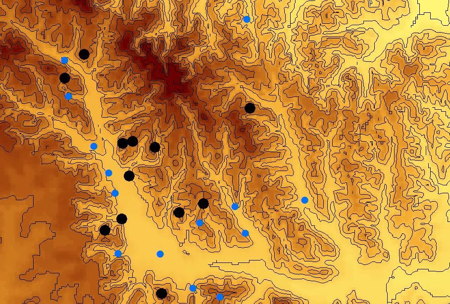
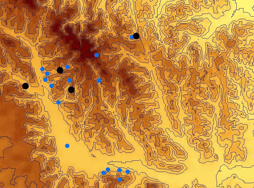
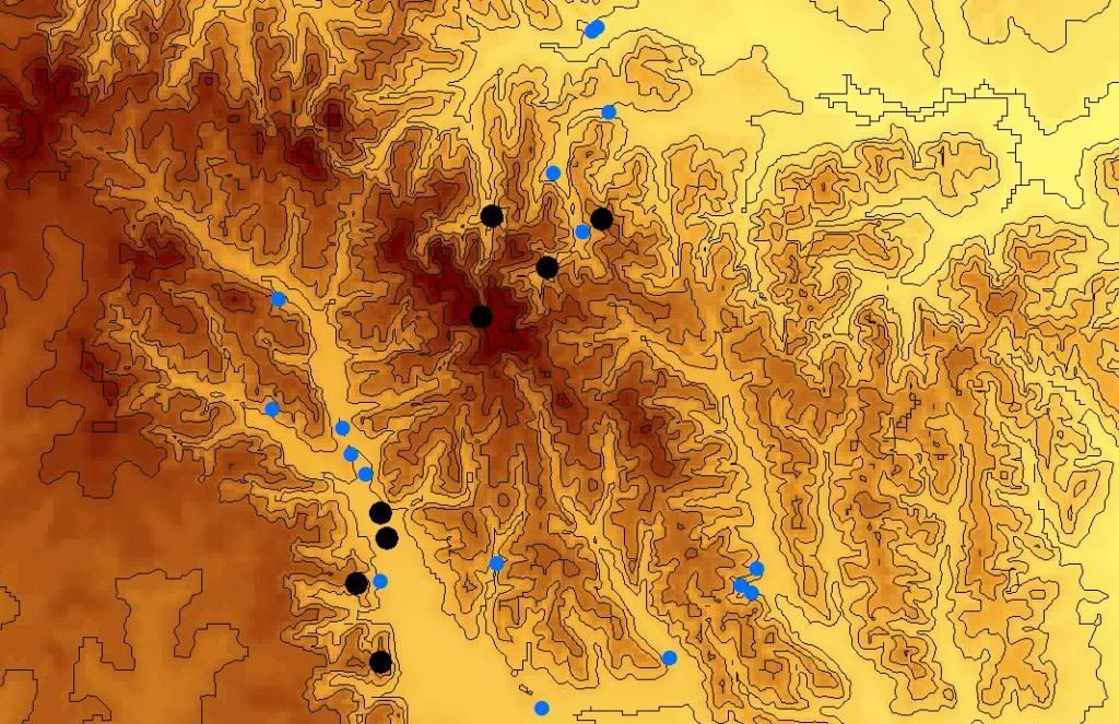
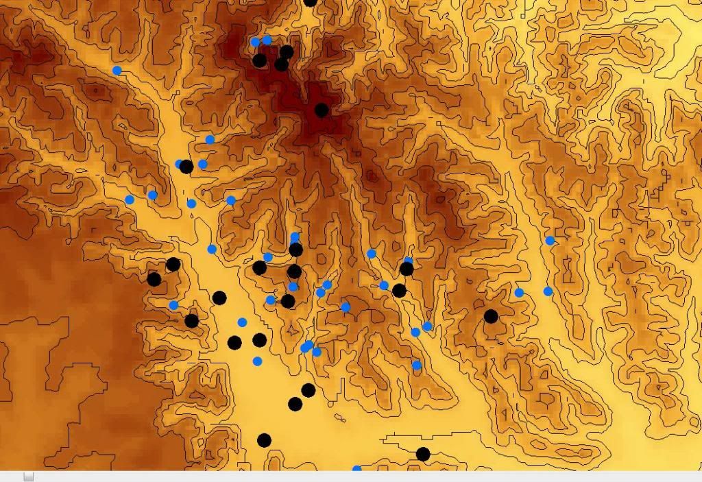
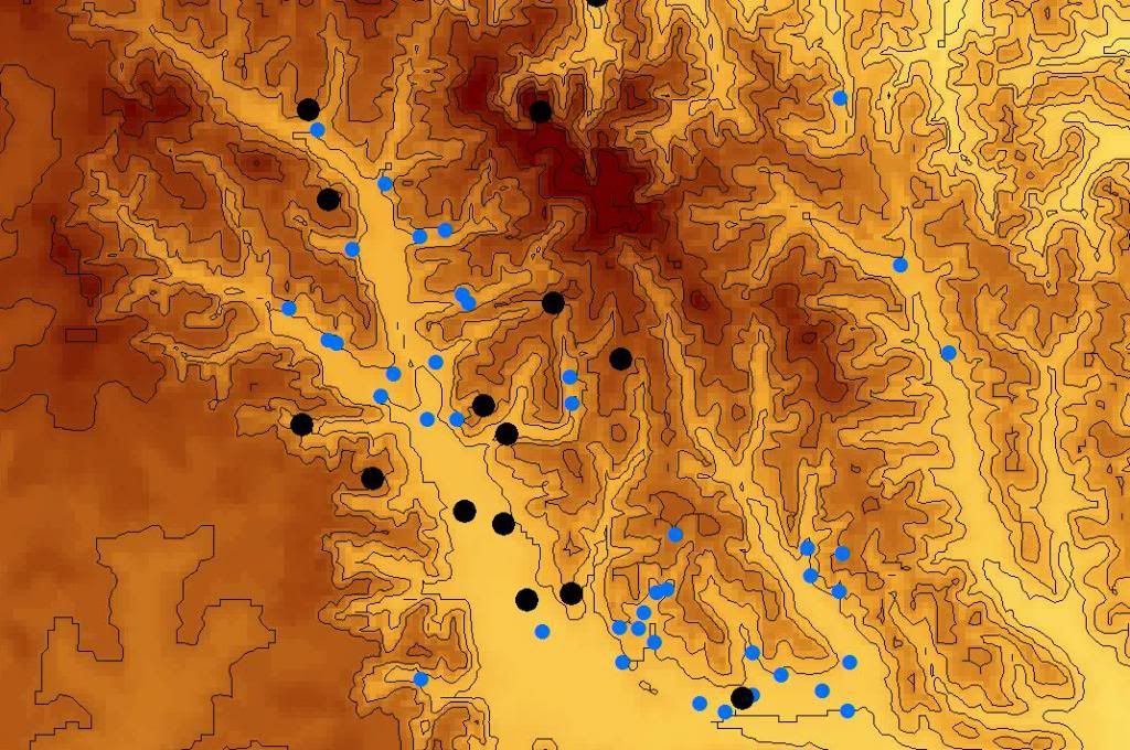
I cannot find the maps of the high wind only points and low wind only points. But when compared, it's even easier to correlate where those dots are situated to the wind direction. In low wind conditions they can't be correlated and their elevation varies. Pay attention to the blue dots and their elevation and distribution to the terrain depending on the wind direction.
This is a fairly large expanse of private/public land (you can see that by the scale on the 2nd map) that I hunt and have hunted for my entire life. It may look as though that large hollow on the southwest side of the maps would be a pasture, but it is actually a river bottom with one of the largest and longest ridges that I have ever seen bounding it to the northeast. Some of it near the southeast end is pasture, but nearly everything on the map is wooded.
Where I hunt in large hills and hollows these lee sides of the terrain and deep holes with pockets of good calm timber can be a great place to set up for awhile and do a little broadcasting.
Anyhow, I thought I'd share with ya'll. If nothing else, maybe a few folks will give it a try one day, and have their revenge on the "illegitimate child" that destroyed their brunch date with their beloved ex-wife.
Austin Hill Final Project 4-19-13
Introduction: Through observations while hunting, fishing and working I have made the hypothesis that high wind speeds will push wild turkeys into areas on the lee side of hills and hollows. Through my reading and learning about wild turkeys over the years, I have learned- byway of statements made in articles from individuals who are wildlife biologists, National Wild Turkey Federation representatives, experienced hunters and woodsmen and other authoritative figures on the subject- that the wild turkey’s senses are handicapped by high wind conditions and rain. It is also understood that predators know this and look to capitalize on an easy meal, and nothing in the woods eats better than a wild turkey. To compensate for high wind conditions, turkeys will move to open areas, lee sides of hills and low areas that are less affected by wind- or so they say. I tend to agree as I work and play in the woods nearly every day and have seen similar behavior. In fact, I have harvested several gobblers slowly glassing and hunting the lee sides of hills and bottoms and open areas during rain and high wind conditions- although I have never made an analytical attempt to prove it. So, on this information and my own observations I form my hypothesis: If high winds are present then turkeys will move to areas out of the wind.
My objective is to see if I can put a pattern to the spatial distribution of wild turkeys in high wind conditions. High winds are a normal part of springtime weather in Mississippi. I will use ArcMap to take point data and try to put together a spatial patterning of turkeys based on the point data’s attribute fields that designate wind speed and conditions.
The materials I used were a Garmin Oregon 450 GPS receiver unit and a field book. I tend to record any type of game animal I see and the weather conditions. If I did not record the weather conditions for that day then I referenced the almanac at weatherunderground.com for wind conditions for that day. In the last couple of years I have used a IOS app on my iphone that was referred to me by an individual. The name of the app is PDF Maps by Avenza. It is a very useful app that gives the user georeferenced USGS Quadrangle Maps that are downloaded in the Avenza store on the app. The USGS maps and the basic version of the app are free. You can cut your cellular data off and still use the application’s maps because they are PDF scanned, georeferenced maps that do not require data services to load- they are downloaded whole into the iphone. The good thing about this is you can use a phone all day with the app because your location is still turned on, but cellular data (which drains batteries) is turned off. Also, PDF Maps is much more streamlined and easy to use than Garmin GPS units and the accuracy (+/- 15 feet) suits the objective of this project just fine. PDF maps allows the user to apply as many attributes as he or she likes to a point, and it also allows the user to create customized folders to store point data. You can also import or export .csv, .gpx, and .kml file types from any source or from PDF Maps to sources that support the filetypes. When I would collect points of any kind on my Garmin unit, I would transfer them to Base Camp . Basecamp is a PC program created by Garmin to collect, store, import, export, etc. data that is collected- whether it be on a Garmin or any other unit. As long as the file type is .gpx you can work with the point data (it also supports line and polygon data). I also used Microsoft Excel, ArcMap version 9.3 and official USGS Quadrangle maps that had information written on them as well to collect, store, manage and display the points and terrain.
The methods I used were point collection, point management, editing of points, projection of points and maps, querying and displaying the results. I transferred all recorded points from past years and current events to PDF maps in .gpx format. The results in the iphone app looked like this:
Edited: too risky
All points in PDF Maps were names by their wind speed and wind direction, i.e. NW 15. Any points that were not recorded with weather information were referenced to an almanac and their corresponding attributes of wind conditions and wind speed were also recorded. Once the points above were suitably imported and edited I exported them to my email as a .csv file and then saved to a USB memory card. I added new attribute tables of wind speed and direction in Microsoft Excel and then exported them into ArcMap. All DEM data was downloaded at www. maris.state.ms.us . I used the projection of the DEM files which I obtained from the metadata off of Maris’s website ( State System > NAD 1983 Mississippi TM). I then added the points to the ArcMap project and used the transform function to align the two data layers. From there I created a raster and then used 3D analysis tools to create the base map. After that I used querying tools to see where turkeys or fresh turkey sign was spotted on “x” wind speed and “x” wind direction to draw a conclusion to my hypothesis.
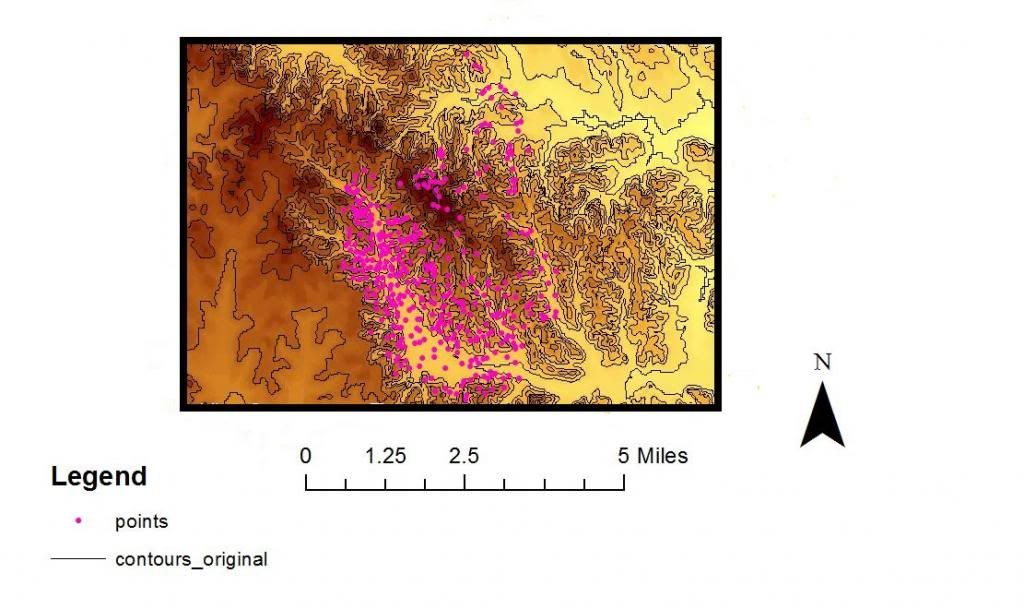
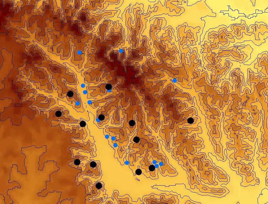
Results and discussion: Below is a view of the map after I loaded the DEM file for ___ County and ___ County and merged them in ArcCatalog. This is before any point data was queried. I created a raster from the Grid Code in Arc Toolbox and ran a surface analysis using “Aspect”, “Contour”, “Viewshed” for my own purposes. The picture shows the points after I created the raster and messed around with the Symbology properties. No point attributes have been selected here.
The models:
SW Wind
SE Wind
NE Wind
NW Wind
East Wind
South Wind

North Wind
West Wind
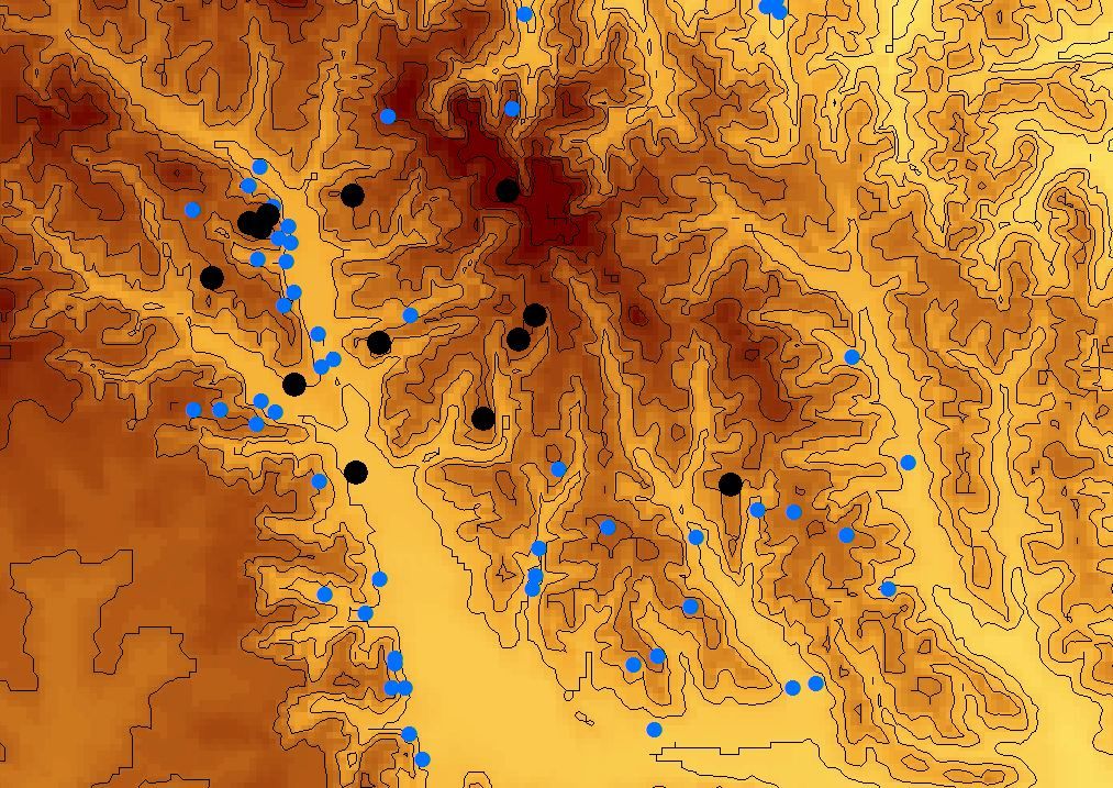
As you can see in the maps and the one above, there seems to be a slight spatial orientation of turkeys due to wind speed and direction. Through more detailed analysis and collection of more points with more attributes assigned like date, time, sex, habitat conditions, etc I believe that you could put a concise conclusion together on how turkeys react to adverse weather conditions like wind and rain.
References: 1) www. maris.state.ms.us
2) NWTF
3) MDWFP
4) ArcMap

